You can figure out which direction is which by looking at the night sky. Humans have been doing this for thousands of years. And, there’s no reason why you can’t find your way today from reading the position of stars and planets.

Key takeaway:
- Stars: These can be navigational aids indicating your latitude and longitude
- Moon: Lunar position in the sky can shine a light on the direction
- Constellations: Indicate the time of night or point to other sky objects
Unlike stars, planets tend to move around the night sky. However, they can still be useful for navigation much like the moon as they move across the arc in the sky from eastward to westward.
By understanding these different navigational aids, you can better navigate through the night sky and reach your destination safely.
Early sailors used stars to navigate
By identifying certain stars and their positions above the horizon, early seafarers could determine their location and direction of travel. An example is Polaris.
The North Star: Polaris is a bright star that is located almost directly above the Earth’s North Pole. Because it is almost stationary in the sky, it has been used as a navigational aid for centuries.
By observing the position of Polaris in the sky, navigators can determine their latitude (their position north or south of the equator).
Sirius, also known as the Dog Star, is the brightest star in the night sky. By observing the position of Sirius in the sky, navigators could determine their latitude and adjust their course accordingly.
Vega is part of the constellation Lyra, which is visible in the northern hemisphere. Navigators could determine their direction and make course adjustments by observing the position of Vega in relation to other stars.
Understanding the Moon: Rising and Setting Directions
Although it can be quite difficult to determine the exact direction of the moon’s rising and setting, there are some basic principles to keep in mind.
While it rises and sets in the east and west, respectively, a full Moon behaves differently than the Sun.
In northern temperate regions like the US or Europe, a full moon rises in the southeast during midsummer and northeast during midwinter, setting in the southwest during midsummer and northwest during midwinter. At midnight, a full moon is generally located close to due south.
The Moon is a fascinating and sometimes slippery object for the natural navigator to tame. There are fast and slow methods for finding direction naturally using the moon, but unfortunately no known fast accurate methods.
Tristan Gooley
Using a Crescent Moon as a Navigation Tool
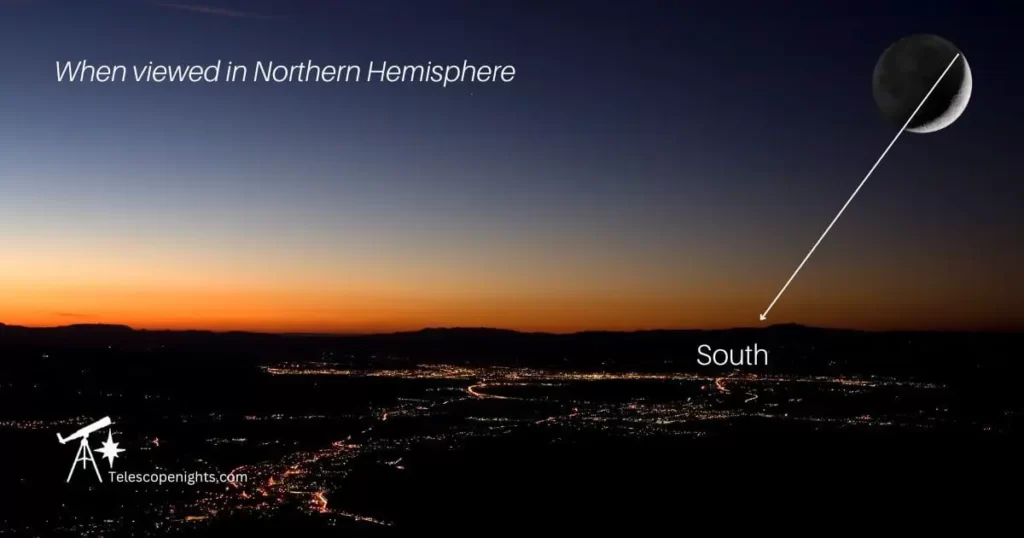
While it may seem unconventional, a crescent moon can still be used for navigation.
Extending an imaginary line from the crescent points to the horizon can roughly indicate the direction of south in the Northern Hemisphere) and north in the Southern Hemisphere.
This method offers a general direction, influenced by environmental factors and the observer’s location, and is most effective in the first half of the night when the moon is visible in the western sky.

Navigating the Night Sky with the Pointers
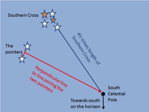
Alpha Centauri and Beta Centauri (Hadar) are two bright stars in the Centaurus constellation, known as The Pointers.
If you are in the Southern Hemisphere, you can work out south, by extending the Southern Cross’ main axis until it intersects a perpendicular line originating from the center of the Pointers.
The intersection of these two lines is the location of the south celestial pole. By dropping a line to the Earth, you can identify the southern horizon (see diagram).

Southern Cross
The Southern Cross (Crux) is a constellation in the southern hemisphere sky.
The stars of the Southern Cross form a specific pattern that is easy to recognize. By using the Southern Cross, you can determine your direction of travel.
It is especially useful for those traveling at night or in areas without landmarks.
An Australian Aboriginal Story of the Southern Cross
Many Australian Aboriginal groups used the Southern Cross to tell them the time of night. By observing the Cross’ tail lying this way or that, they would track the time as accurate as every two hours throughout the night (Source).
Using Astronomy for navigation has cultural significance.
stars and constellations used by the early Polynesians to navigate the oceans
The early Polynesians relied on stars to navigate their way in the Pacific Ocean what’s known as a star compass.
There was a multitude of star types involved, but included were Sirius, Canopus, and Vega. Also included were the Southern Cross and the constellation of Orion.
What is special about Sirius, Canopus, and Vega is that they are the brightest magnitude stars and are visible from many parts of the Pacific Ocean. They also have unique positions in the sky that make them useful for navigation.
Sirius rises and sets at different times throughout the year depending on the observer’s latitude. Because of this, the Polynesian navigators could use Sirius to determine their position north or south of the equator (latitude).
Canopus is located near the southern celestial pole. Because Canopus is almost stationary in the sky as the Earth rotates, the Polynesians could use Canopus to determine their longitude (their position east or west of a reference point).
And Vega is part of a recognizable constellation, Lyra, in the Northern skies that can be used to determine direction.
These factors made these three among other stars particularly important for Polynesian wayfinding and helped seafarers navigate the vast Pacific Ocean.
The Polynesians’ knowledge of celestial navigation was passed down through generations and played a crucial role in their ability to explore and settle the many islands of the Pacific.
Navigating your way around the night sky
Orion’s Belt is a group of three bright stars, Alnitak, Alnilam, and Mintaka, located in the constellation Orion. Because of their brightness and distinctive pattern, the three can help you to navigate the night sky.
If you’re from the Southern Hemisphere, look for these three bright stars in the Saucepan. They form the Saucepan base (which is Orion’s Belt to Northern Hemisphere observers).
In the Northern Hemisphere winter sky, drawing an imaginary line through these three stars and extending it downwards leads to Sirius, the brightest star in the sky. Similarly, extending a line upwards from the middle star leads toward the red supergiant star Betelgeuse.
In the Southern Hemisphere calendar, you would extend the line from the Saucepan’s base westward in summer to lead you towards the Pleiades. Extending it eastward will lead you to Sirius and a line going downwards from the middle star to Betelgeuse.
By using this method, and with the help of star map apps or planispheres you can navigate your way across the night sky.
