
It’s fairly easy to pick out the bright planets in the night sky, but what about other objects of interest overhead? You can download sky map apps for your mobile device, which helps. But the best finder charts are the manual ones, for a few reasons. Here, I cover these plus some tips on using and getting the best planispheres for the novice amateur astronomer.

David H. Levy’s ‘Guide to the Stars’ chart for the Northern hemisphere
More info at Amazon (affiliate link)
Astronomy 101: What is a planisphere?
A planisphere helps you identify that bright star, star clusters, or the constellations visible on any given night. It is a manual tool that is hand-held. Diagrammatically it shows the planets and constellations with emphasis on the brighter stars.
Also called a sky or star wheel, a celestial planisphere, or a night sky planisphere. Sky maps, star maps, star charts, and star atlases are also names that are used interchangeably.
It pretty much gives you the same information as a chart but a planisphere usually involves two discs joined at the center. You simply turn the discs to align the date and time of night to show the stars visible to you and their position and then orient yourself to match the plane.
Planisphere vs. Chart
You could say the difference between a planisphere and a star chart is that a planisphere has more than one disc or dial that rotates. One has the date, another the time of day, and another the ‘sky’ relative to Earth. While a chart is a set map at a point in time. Nonetheless, the terms are often used interchangeably to mean the same thing.
Also, be aware that not all show bright planets.
How do I use a Planisphere?
You use a planisphere by simply moving the discs so your observing time and date coincide to find what’s visible in your sky and the position of the celestial objects such as constellations. You need to orient yourself in the North-South direction so the planisphere matches the sky.
Why use manual star charts / sky maps
Five reasons when using a manual piece of equipment to identify that brighter star or other celestial objects in amateur astronomy beats using apps:
- You don’t have access to digital means of looking up the celestial bodies.
- You’re at a location where you can’t get internet coverage.
- Looking at a hard version map makes more sense to you.
- You’re using your mobile device for another purpose and it is inconvenient to toggle between apps on your device to identify that night sky object.
- You aim to learn more. For beginners, the manual star finder charts that include grids are especially a great learning tool for getting to know the celestial coordinate system.
In any case, I find having a tangible star chart is a handy tool for investigating and finding your way around the night sky.
Best sky maps for beginners
You’ll find Terence Dickonson includes all-sky charts in his informative NightWatch: A Practical Guide to Viewing the Universe. And for Australian or southern hemisphere enthusiasts, there’s the Astronomy Year guide to the night sky that has these all-sky maps.
But for a planisphere with rotating dials, I recommend the David Chandler sky maps because of their level of detail. They are inexpensive and you can get them at Amazon.
David Chandler brand of Planisphere
David Chandler has some of the best planispheres for beginners because of their precision. He publishes them for the southern hemisphere as well as a range of latitudes in the northern hemisphere and they come in sizes large and compact, suited for traveling to locations for stargazing.
North Hemisphere
- The Night Sky 50°-60°
- The Night Sky 40°-50°
- The Night Sky 30°-40°
- The Night Sky 20°-30°
Southern Hemisphere
- The Night Sky Southern Hemisphere
 Star Finder")
The Night Sky (Large) Star Finder
available at Amazon (affiliate link)
Tips on using star charts for beginners
- Make sure your timezone matches the skymap or chart. Daylight Saving and other time shifts may confuse the issue.
- Realize that the limiting magnitude of the stars (5.5) will hinder what you see with the naked eye. You will need to use a pair of binoculars or your astronomy telescope to see the fainter stars marked on the maps.
- Under dark skies, in areas away from urban light pollution, you should see everything up to that limit.
- Use a distinctive star pattern to orientate yourself and rotate the chart.
- Get to know what the grids on the chart mean. In most, you will have the right ascension (hrs; vertically or N to S) and the declination lines (degrees; running across).
- Look for objects with the same declination (degrees) as your latitude, as these will pass directly overhead (the Zenith). For example, if you were near the Tropic of Cancer, look for the declination +23.5°. In the Southern Hemisphere look for negative declinations, e.g. if you were at the Tropic of Capricorn, look for the declination -23.5°.
- Your chart may also show the paths of the planets.
- Make sure to use a red flashlight to preserve your night vision rather than a bright light.
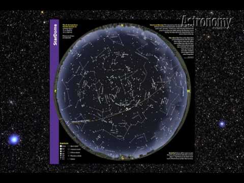
How do you use a sky map?
This video by the editor of the Astronomy magazine explains the conventional one-sided planispheres that you find in astronomy books or magazines.
Interactive sky chart
This is a handy link to an interactive sky chart that you can configure to your location and the desired time. You can also download it as a PDF to take with you to your favorite spot for stargazing.
More tips on using sky maps and night sky watching
Get to know what’s up there in space.
In viewing the night sky, apart from the constellations, stars, and planets, you might come across unexpected sightings or moving objects.
Is that a satellite you’re seeing? Is it the International Space Station (ISS)? You can find out here.
Also, you can find out real-time space weather and near-Earth asteroids here.
What else can you do with a sky map?
You can make your own sky map by tracing over a printout of a star chart. This is called “skymapping”.
Sky mapping is a fun activity for kids who like to explore their world.
Source material
- Nightwatch, a Practical Guide to Viewing the Universe by Terence Dickinson (available at Amazon – affiliate). This book contains sky charts and has a spring binding so is practical for use on location.
- Astronomy Australia Year Guide to the Night Sky (affiliate link) by Wallace, Dawes, and Northfield includes all sky maps and much more information for stargazing down under
If you’re new here and starting out with astronomy, be sure to check out our Beginner’s Page where you will find helpful guides and tips to get more out of your stargazing experience.
Or, see our Buyer’s Guide Section if you are looking to buy astronomy gear and need some help sorting through the numerous options.